Skyline View of Bangkok

A week ago, a couple we know was in town from Chicago. They had a twenty-four hour layover on a cruise making its way from Singapore to Hong Kong. We met them for drinks at the rooftop bar on the Marriott Sukhumvit Hotel.

The hotel opened less than a year ago and is only a few blocks from our house. I had never been there but was amazed at how spectacular the views are – the roof affords a full 360-degree view of the city.

2014-03-007

This first view is looking to the east and southeast along Sukhumvit Road. You can see the BTS Skytrain running along the road and Ekkamai station is just blocked by the red condo building, located between the Gateway Mall (also red) and the temple complex. That makes for an interesting contrast, no?

2014-03-05 6

This photo picks up from where the previous one leaves off, looking from the southeast to the west. You can see that we are actually not very far from the Chao Phraya River and the port area – if you look really closely, you can see their cruise ship docked. You will notice that the main part of the city is to the west, where the concentration of high rises is much denser.

2014-03-05 5

This picture continues from the far end of the bar in the previous picture. It looks from the west to the north and covers the entire Thong Lor neighborhood where I live. The BTS Skytrain station is on the left and you can see the line running into town along Sukhumvit Road. This neighborhood is more residential with lots of condominium towers, restaurants, and shops.

One thing that really amazes me about Bangkok, compared with many cities, is that there are high rise buildings all over the place with no real defined “centers” for the city. On one level, I think it makes the skyline a bit bland as there is no focal point. But at the same time, maybe being so spread out saves us from all having to commute to just one area. Who knows?


The Hidden Verdancy of Bangkok

The thing about Bangkok is, it isn’t a very pretty city. Being in a tropical climate, I always expect that it will be a lush, verdant city. Even though I’ve lived here more than seven years, I still have that expectation somewhere in the back of my mind. The reality, though, looks a lot like this:

At least, that’s how it looks from the street level. The buildings are built close to the roads, with only narrow footpaths that are only occasionally dotted with trees. Those trees are usually subject to harsh pruning by laborers armed with sharp saws and little horticultural knowledge.

P1120419

Over time, my understanding of Bangkok’s relative verdancy has evolved. What I have come to see is that the city has a lot of green space, but that most of that green space is not public. Sure, as you walk down the alleys and streets, you may see some trees and bushes. For the most part, though, they are on private property, peeking over high walls. As a result, you walk in the full heat of the tropical sun.

Compare this with Singapore (pictured above) or even Kuala Lumpur, cities with mature trees lining the public footpaths, providing shade, cleaning the air, and making the city more pleasant. Now, don’t worry – I’m not about to turn this into a Bangkok-bashing, Singapore-loving entry. I just find the comparison to where our greenery lives interesting. 

When you rise above the street level, as in this view from the Conrad hotel in the particularly lush Wireless Road neighborhood, you can see that there is quite a bit of greenery in Bangkok, although as mentioned before, much of it is not visible from the streets.

In fact, some of the grander houses live in a lush, tropical paradise. Except for the high rise buildings looming overhead, you would think you were in a jungle!

Sukhumbhand Paribatra, elected this past Sunday to a second term as governor of Bangkok, has promised to radically increase the amount of park land. By most estimates, Bangkok has less than one-tenth the amount of green space per resident compared with an average city. Let us hope that some of this green space can be expanded out of parks and into our everyday lives.

Of Soi and Motorsai

Thailand is a country of cat-nappers. Wherever I travel, I see plenty of people who, in their boredom, lethargy, or exhaustion, take every opportunity to shut their eyes and rest. Maybe it is the heat and humidity?

On the list of jobs I would not want to have is the motorcycle taxi driver or khon kap rotmotorsai. While the offices of Bangkok are filled with women, the men from the countryside find jobs like this one. For a fee paid to the mafia and a license paid to the government, they receive a colored vest and an assigned stand at the mouth to one of the city’s many long soi or alleys. 

Inhospitable to pedestrians, the soi are usually too narrow, too winding, and too sparsely populated to justify mass transit. Instead, we flag down a rotmotorsai, hop on the back, and whiz our way to the mouth of the soi where we catch a taxi, bus, or train onward. Dangerous? Yes. I only ride the motorcycles on our soi, where the drivers recognize me as a regular and are familiar enough with the traffic on the street to know where caution must be paid. 

Why are our streets laid out in a network of long, narrow soi? It is thanks to the rice-growing past of the central plains of Thailand.

As you can see in the picture above, rice paddies were laid out in long, narrow strips that connected to a main canal or road. As the paddies were drained, paved, and developed (the housing developments are the strips of mostly red roofs) the streets followed the long, narrow contours of the agricultural past. A map of Bangkok shows that legacy: thoroughfares a kilometer or more apart with long, narrow streets stretching out from them. Few of those streets, though, connect the larger thoroughfares.

The result is that many of us live some distance away from major streets and if we aren’t driving, have to find our way out of the soi under an unforgiving sun. It’s enough to make you cave in an ride on a motorcycle taxi or, perhaps, to want to take a nap.

Tearing Down a Shophouse

Each city has its own development  rhythm. Buildings are constructed then subsequently modified or added on to. Sometimes the buildings are torn down to make way for newer buildings. In some cities (think Florence, Italy) the rhythm is very slow. In other cities (Hong Kong!) one can be surprised by how staccato the rhythm is. Here in Bangkok, it is somewhat in between, though closer to Hong Kong than Florence.

A few weeks ago, I noticed that a pair of shophouses adjacent to the Thong Lo Skytrain station (the one at the mouth of our soi) were being demolished. The process took several days and was done largely by hand – laborers with sledgehammers started at the top of the building and deconstructed it, floor by floor.

P1200890

Interestingly, they are not removing the entire row of identical shophouses, just these two. The demolition process exposes the intimate way in which the buildings are connected: ghosts of the back stairs can be seen on the wall of the remaining shophouse. People are apparently still living next door to the demolished buildings: laundry is hanging on the roof area and tarps have been raised to keep the dust out.

P1200893

The demolition also exposed a large open space that I never knew existed behind these buildings. It looks like there may have been a small pool back there. As of yet, there are no signs announcing what is to happen with this space. The house to the left is a large private home on a lot covered with a pond and lots of old trees. Behind the open space is a large but shadowy hotel (the orange building) and to the right is an apartment complex (in green). I would guess that these shop houses probably date to around the 1960s so they are being replaced within three generations.

I look forward to seeing what development happens here. It seems too small for a condo – lord knows we have plenty of those sprouting up all around Thong Lo station! – but stranger things have happened.


Foundation Poured for Central Embassy

P1200558

While visiting the Central Chidlom department store the other day, I caught this picture of the construction progress on Central Embassy, the new 37-story high-end retail and hotel complex that is expected to open in 2013. The piles have been driven and foundation concrete had been poured. Subterranean work continues and I’d expect to see columns start to rise in the near future.

Central Embassy 2

The design is eye-catching, eight stories of retail topped with a twisting tower (to house Bangkok’s first Park Hyatt hotel) meant to echo a double helix. The building is covered on the outside with glimmering diamond-shaped tiles that recall traditional Thai temple roofs. Central Embassy will connect with the existing Central Chidlom complex through the walkway on the left of the picture. A bit harder to see is a second walkway, in the center-right of the picture, which will connect to the Ploenchit BTS Skytrain station.

Here’s an aerial view that I annotated to help orient you:

Central Embassy 1 Annotated

The complex is built on land bought from the British Embassy. As one of the last undeveloped properties in the very pricey Withayu-Ploenchit area, the sale brought in hefty proceeds. In a bit of a kerfuffle, many locals were incensed that the British government profitted so handsomely from the sale of land that was gifted from the Thai government many generations ago. Finally, the Thai government clarified that the land had been given to the British government and was theirs to do with as they wished.

I suppose you could (easily) argue that the last thing we need is another mall and another hotel. No argument from me. That said, I like that we’re seeing continued infill development around transit lines. This increased density is preferable to continued sprawl. Not that the infill is somehow eliminating the sprawl, but you get the idea. Also, the design of this building is unique and contributes to Bangkok’s continued ascent from an architectural backwater to a city with an interesting skyline.

Extra: Here’s a link to a snazzy promotional video for the new complex, giving you all sorts of aerial fly-bys from different angles.


How Does My Garden Grow – Pt 4: First Harvest

With the US Thanksgiving holiday just a few days away, it seems fully appropriate that I was able to recently celebrate my first harvest from my balcony garden.  It was a limited harvest – one beet, one radish, and two cherry tomatoes – but at least it is a start, right?  For those of you who have missed my videos, I filmed and edited a new one to mark this momentous occasion.

P1180254

The harvest was a small one, but I was excited with it nonetheless.  On the left is a golden beet, on the right is a type of heirloom radish called a watermelon radish.  It is supposed to have a light green skin with a pink interior.  The skin was kind of a pinkish white instead.  Behind the two roots are my carrots which are slowly growing.

P1170384

Raindrops on the leaves of my third tomato plant.  Once we hit the start of October – the end of rainy season – the weather rapidly changed.  We’ve had significant rainfall only two or three times since then and my south-facing balcony has been bathed in direct sunlight for about 7 hours a day.  The plants have definitely enjoyed the sun, although I’ve had to be diligent about watering.

P1170330

One curious thing is that my tomato plants – both cherry and beefsteak – have had a problem with pollination.  So far only two fruits have grown.  I’ve not seen any bees around my plants but according to my online research, tomato plants are self-pollinating.  One technique recommended in some videos is to give the plants a good shake to encourage the pollinating.  So far that hasn’t seemed to help.  Plenty of blossoms come and go, but few ever become fruit.

P1180257

And there they are, my two cherry tomatoes.  Organic, homegrown, and mighty tasty.  Now if I could just get a few more of them off my plant, which is nearly three meters tall!

P1180269

Inside of the watermelon radish.  It had a nice flavor, less sharp than the conventional red radishes you see at the market.

P1180268

Golden beet.  I have only seen red beets sold in Thailand so was very excited to have golden beets.  What I’ve decided, though, is that root vegetables are a poor use of limited container space.  I need to focus on vertical plants – tomatoes, peppers, eggplant, etc. – where I can get more yield per square meter of soil.  Of course, I guess the tomato plants haven’t really panned out yet, have they?

Here’s the video of the autumn 2011 harvest.

P1180279

The healthy salad I made from mostly store-bought vegetables and my few container garden vegetables.  The shredded golden beet is on top, some sauteed beet greens, and the radish.  Success!  Stay tuned for more gardening developments.

Previous entries on this subject:

How Does My Garden Grow – Part 1: Defying Gravity 
How Does My Garden Grow – Part 2: A Move to the Sunny Side
How Does My Garden Grow – Part 3: Back to Seedlings

Skytrain Sukhumvit Extension Opens

Transit Map 2011-08 

Another piece of Bangkok’s transit network puzzle fell into place on August 12, as the 5-station extension to the BTS Skytrain Sukhumvit line opened.  After more than a year’s delay caused by a problem ordering track switching mechanisms on time, passengers can now travel all the way to Soi Bearing (Sukhumvit 107).  This extension gives access to the Bang Na district, a very congested area of the city that has long been in need of additional mass transit.

P1150939
Updated map on the ticketing machine obscured the day before opening.

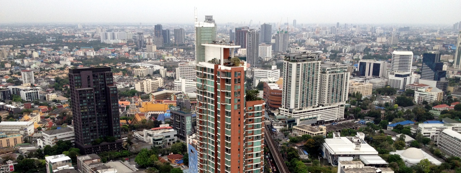
The BTS Skytrain, the first of Bangkok’s three rail transit systems, opened in December 1999 and currently operates a 55-km network composed of two lines and 32 stations.  An average of about 472,000 trips are made on the system each day, with many days exceeding the half-million mark.

P1150956

The five new stations all have the same design with the the tracks running through the center of the station and two platforms on the outside of the tracks.  An improvement in these news stations, along with two stations on the Silom line that opened last year, is that the roof covers the entire space.  The original stations have an opening in the area over the tracks, resulting in passengers being partially exposed to the elements, especially the when the sun is lower in the sky.

P1150958

One improvement – all the new stations have elevators.  Most of the stations in the system do not have elevators, making travel by train inconvenient for people in wheelchairs (who would have a hard time with most of Bangkok’s sidewalks, too) and parents with strollers.  In front of the elevator doors are three safety posts, the purpose of which is not clear.  Perhaps they are meant to keep someone from rolling out of the elevator and onto the tracks.  I guess if someone was backing out they may not see where the edge of the tracks is, although they would have to travel a couple of meters before reaching it. 

P1150952

One challenge to mobility is that the stretch of Sukhumvit Road on which these new stations are built, has narrow sidewalks.  The placement of station stairs and escalators essentially blacks the sidewalks, leaving no room for wheelchairs or strollers or even for two people to pass each other.  This seems like a problem that could have been overcome, although I have noticed that the traffic lanes actually narrow as they pass beneath the stations, so perhaps squeezing out more space was impossible. 

P1150982

Fortunately, there are signs of some amount of foresight in the construction of the track viaduct and support structure.  At the point between Udom Suk and Bang Na stations, the track viaduct is wide enough for two pairs of tracks.  In the picture above, just above the pedestrian bridge, you can see the end caps for two additional tracks.

P1150983

Turning 180 degrees and looking southeast along the tracks, the left side of the next support beam has a pad on which one of the track viaducts could rest.  The train track passes between two levels of the expressway at Bang Na.  One of the planned future extensions, although there is no specific timeframe in which it will be built, is to have a spur line branch off from the main Sukhumvit line and head northeast along the expressway.  This extension would include a stop at the BITEC convention center.  Currently, the closest station (Bang Na) is about a kilometer away, although an indoor walkway is being constructed to connect the station and the convention center and looks set to open in a few months.

P1150997

The problem with the new five-station extension is that it is projected to add some 100,000 additional trips to the system each day, but during rush hour the system is already at peak capacity.  This view of Asoke station, taken at 6:30 pm on a weekday, is too typical. 

P1160003

The layout of station entrances, something that would be difficult to change significantly, is narrow and results in ticket machine lines running into the fare gate lines running into still other lines. The entrance areas at the new stations seem to be wider, which will hopefully help.  Another thing that would help at existing stations is to remove small retail kiosks adjacent to the fare gates.  These consume real estate that could ease the congestion of foot traffic.

P1160012

The capacity problem is less about station entrance design, though.  It is primarily an issue of not enough train cars.  There are 35, three-car Siemens trains on the system.  Last year, following the opening of two new stations on the Silom line, 12, four-car Bombardier trains were added, running exclusively on the Silom line.  This additional capacity was immediately swallowed up.  In October 2010, the operator of the Skytrain ordered an additional car for each of the three-car trains, although it seems these will not arrive until at least next year.  Also next year, an additional four-station extension will open on the Silom line.  Dr. Pichet Kunadhamraks of the Ministry of Transport’s Office of Transport and Traffic Policy and Planning, indicated by email that he thinks these additional train cars will satisfy demand.

Earlier this year, the Transport Minister asked for residents’ patience until 2015, by which point some 60-plus kilometers of additional rail lines will have opened, adding to the approximately 103 kilometers currently operating.  It will be interesting to see whether these new lines and extensions open on time and, if they do, what impact they have on the city’s traffic.  Bangkok is a city that would be well-served if it had a comprehensive network of rail transit.  It would also be well-served by a bus network that feeds into that network, rather than largely duplicating it.  That, however, is a topic for another day.


Singapore Light Rail and New Urbanism

During a March visit to Singapore, I decided to ride the subway out to the nether reaches of the island to visit the light rail lines.  Singapore has three light rail lines that form four loops connecting to stations in the rail-based public transit network.  They were built with the express purpose of serving master-planned housing estates, giving residents a door-to-door rail service that allowed them to get around without increasing road-based traffic.

The light rail itself is clean and efficient, with the automated cars running regularly on elevated tracks that weave between housing towers.  Below is a video that overviews my experience on the system, including a startling discovery I made about how technology is used to solve a perhaps unforseen privacy problem.

Matters of urban planning and design have always interested me and for a short while in university I was an urban planning major.  Examples of transit-oriented land use, like the developments that surround the light rail lines in Singapore, make me think about ways that similar lessons could be applied in the United States.

Suburban Sprawl

A country with a plentitude of land, since World War II development in the US has been oriented towards the automobile, resulting in more and more sprawl and fewer and fewer neighborhoods where one can walk from home to anywhere useful.  With rising fuel prices and ever-increasing congestion on the roads, it amazes me that there has been continued resistance not only to public transit, but transit-oriented development.

Orenco

There are a few examples in the United States of what is sometimes called “New Urbanism”, a design philosophy that promotes more walkable and transit-friendly neighborhoods that include mixed use buildings – shops, businesses, and residences in the same general area.  Not unlike traditional older neighborhoods in an urban environment, there are small shops on the main streets, some apartments overhead or in the surrounding blocks, and then single-family dwellings set further back.  Orenco Station, a neighborhood in the Portland, OR area is a good example of this type of planning.

(Comparing the “suburban sprawl” photo earlier in this entry with the master plan for Orenco Station, you’ll notice that suburbia has a lot of dead-end streets, which means there’s always a long way to go to get out of the neighborhood.)

Promenade2

Some defining elements of this new style of development include:

  • The neighborhood has a discernible center. This is often a square or a green and sometimes a busy or memorable street corner. A transit stop would be located at this center.
  • Most of the dwellings are within a five-minute walk of the center, an average of roughly ¼ mile or 1,320 feet (0.4 km).
  • There are a variety of dwelling types — usually houses, rowhouses, and apartments — so that younger and older people, singles and families, the poor and the wealthy may find places to live.
  • At the edge of the neighborhood, there are shops and offices of sufficiently varied types to supply the weekly needs of a household.
  • An elementary school is close enough so that most children can walk from their home. There are small playgrounds accessible to every dwelling — not more than a tenth of a mile away.
  • Streets within the neighborhood form a connected network, which disperses traffic by providing a variety of pedestrian and vehicular routes to any destination. The streets are relatively narrow and shaded by rows of trees. This slows traffic, creating an environment suitable for pedestrians and bicycles.
  • Parking lots and garage doors rarely front the street. Parking is relegated to the rear of buildings, usually accessed by alleys.

grand-way-in-st-louis-park-mn

As I look at these design elements, I see of list of things that have a whole lot of “pros” and very few, if any, “cons”.  While the US will never go the route of Singaporean style land use – there’s no comparable acquiesence to the wisdom of the government, for starters – it does seem that a more comprehensive approach to land use would benefit the United States and our quality of life in the decades to come.

Further reading: Interesting blog entry titled “Five Causes of Suckiness in American Architecture“.


Terminal 21 Nears Completion

In November 2009 I first wrote about the construction of a new mall at the northwest corner of Sukhumvit and Asoke roads called Terminal 21.  I visited the subject again in February of this year as part of an entry about the profusion of malls being built along Sukhumvit Road.  In the weeks since, I’ve stopped by the site, which is easily visible from the outbound platform of the Asoke BTS Skytrain station, to view the last steps of construction.

Since the mall is literally right next to both the Skytrain station (elevated) and the subway station, it should benefit from easy access.  But, in a city with strong sunlight, heavy rain showers, and lots of traffic, the more convenient and enclosed you can make that connection, the better.

P1100342

Because of that, one of the things I’ve been observing and thinking about is how the main entry area (shown above) will connect with the two rail stations.  You can see the long concrete deck that will be the main entry area, wrapped in green construction netting.  One entrance is on the left, outlined in red metal beams, and the other is at the right end where there is a bit of a canopy being constructed.

P1100343

On the west end of the deck, I can easily see how a bridge might be built to connect to the Skytrain station, which has blue-covered stairs seen on the left of the picture.  In this picture, taken a few weeks ago, I anticipated the potential bridge with orange lines.

P1100849

Sure enough, by last week they were pouring the concrete reinforcements for the bridge and I imagine in another week or so they will be laying the beams for the bridge.  This will lead directly to the entrance of the Skytrain station, which I fear is a bit small to deal with the amount of passengers that may be passing through the space.

P1100345

The more uncertain question is what they will do with the other entrance to the mall.  In the picture shown above, taken a few weeks ago, they were demolishing the sales office for the mall and I anticipated (in orange lines) that maybe a bridge would be built connecting to the escalators that descend to the subway.  The escalators are in the building with the bright blue roof that has one red segment.  While some re-jiggering of the wheelchair ramp in that area would be necessary, it seemed to be an easy way to get people directly to the subway, short of a tunnel leading into the station itself.

P1100732

After they demolished the former sales office and finished off the edge of the entry deck, it is no more clear what they will be doing.  Certainly it will be some sort of bridge, but how it connects to anything else remains a mystery.  Complicating matters further, there is a narrow alley you see in the photo above.  This space contains a small shrine that belongs to the Asoke fresh market, located in the building with the dingy white-washed wall.  Any bridge connecting to the escalators to the subway would have to cross over this alley.  I guess there is little to do but wait and see. 

P1100852

One other thing that caught my eye: there seems to be a “moat” built around the edge of the mall.  The other day there was quite a bit of water flowing down it.  Not sure if this is part of the drainage system and will be covered with grilles or what.

P1100857

The other night while waiting for the train after my Thai lesson, I noticed they had the interior lights on for the first time.  It may be a bit hard to tell, but the interior is largely finished.  They are laying the tiles on the main floor and most of the shop entrances are decorated already.  I think they will be open in the next few months.

Central Plaza Rama 9 March 2011

Not that far away from Terminal 21 – in fact, just two subway stops north along Asoke/Ratchadapisek Road – There is another mall being built.  This is Central Plaza Rama 9.  There is an additional development that is supposed to happen behind it – a large four-tower condo complex.  In fact, the developer was floating the idea of building a monorail that would go down Ratchadapisek Road (to the right in the picture above) and connect with the Airport Rail Link terminal at Makkasan. 

The view above is looking east from atop Fortune Town IT Mall, with the Thailand Cultural Center off to the left and Rama IX road following the bridge on the right.  Pardon the inexpert job done stitching three photos together to create this faux fisheye lens effect.


Curbing Our Walking Space

After writing about some potentially good news for pedestrians in Bangkok, I have to strive for some karmic balance by writing about something else what is currently underway that is impinging on the foot-friendliness of a soi in my neighborhood.

“Soi” is a word in Thai that is often translated into English as “alley”.  It means a smaller street, often not connecting, that branches off a major road.  The neighborhood I live in is in the midst of a veritable maze of sois, some of which have footpaths (sidewalks) and others of which don’t.  One main soi on which I regularly have to walk has undergone some road construction this past week that ended up with a pedestrian unfriendly result.

P1100247

This particular soi is called Thong Lor Soi 9, indicating it is the ninth soi off a larger street called Thong Lor – which is itself a soi of Sukhumvit Road, Sukhumvit Soi 55, to be precise.  (Confused yet?)  Soi 9 parallels a small khlong (canal) that is really more of a drainage ditch with some stagnant water in it.  There isn’t much space and when you walk along it you have to be careful of passing traffic.  Thankfully, though, there is a wide dirt shoulder that you can step onto if you become concerned about the passing vehicles.

Two weeks ago when I saw workers shoveling gravel along the khlong side of the soi, I was optimistic that perhaps they would widen it just a bit, making a little more room for the many pedestrians who walk this soi from the residential area to the main street where all the shops and markets are.

P1100249

Unfortunately, the plan was not to widen the street but instead to add a curb along the side of the existing street.  Not that I’ve seen it happen, but perhaps they are suddenly concerned about vehicles ending up in the ditch like some pilot of a South African 737.  Or, more likely, they are trying to channel rain water into the storm drains (concrete rectangles with metal grates in them in the picture below) instead of into the khlong. 

P1100431

The net effect for pedestrians is that now you really have to walk in the street.  An easy step off the street now involves stepping over a curb and onto uneven ground, increasing the risk of tripping or ending up on your butt in the khlong.

P1100434

From a pedestrian perspective, the best solution would probably be to install a wide pipe in place of the khlong and pave over that area with a wide footpath.  They did this on part of Sukhumvit Soi 38 (above) and it is beautiful.  Yes, there isn’t as much greenery although that could be addressed in several different ways.  But you do have one of the widest, smoothest footpaths in the city, complete with ample curb cuts. 

I’m curious to see whether Thong Lo Soi 9 ever receives similar treatment.  For now, I’ll just have to be that much more careful when walking along the soi.