Running around the block

https://graphics.reuters.com/world-coronavirus-tracker-and-maps/countries-and-territories/thailand/

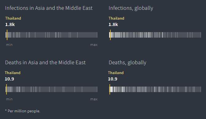
Wave three of COVID-19 has arrived in Thailand. Our infection and death rates per million are significantly below many other nations, but after the B.1.617 variant (the so called “Indian variant”) reached Thailand despite our borders ostensibly being closed, our earlier good fortune of few infections gave way to the realization that Thais are susceptible to COVID after all.

While generally compliant with mask mandates, many let their guard down after a year and ill-advised gatherings at illicit pubs and “entertainment venues” in the hi-so Thong Lor neighborhood were super-spreader events that ushered in wave three, just before the Songkran holiday in mid-April. The government, perhaps loath to cancel the Songkran for a second consecutive year, thousands of Bangkok’s upper crust traveled to Phuket, Chiang Mai and other holiday destinations. Large, mostly unmasked gatherings there helped spread the virus across the kingdom and then, the newly infected returned to spread the virus further across Bangkok.

A month and a half later, we are in a partial lockdown. Restaurants operate at one-quarter capacity with only one guest to be seated at each table. They close early for dine-in and no alcohol is served. The borders are still closed except for those with Certificates of Entry from the Thai government (in addition to visas and other paperwork) who undergo a 15-night quarantine regardless of their vaccination status. I’ll talk more about that in an upcoming post.

To top it off, among the restrictions has been the closure of gyms (understandable) and public parks (less so). This means my running, my preferred form of exercise, is now done on the sois of Bangkok in the pre-dawn darkness.

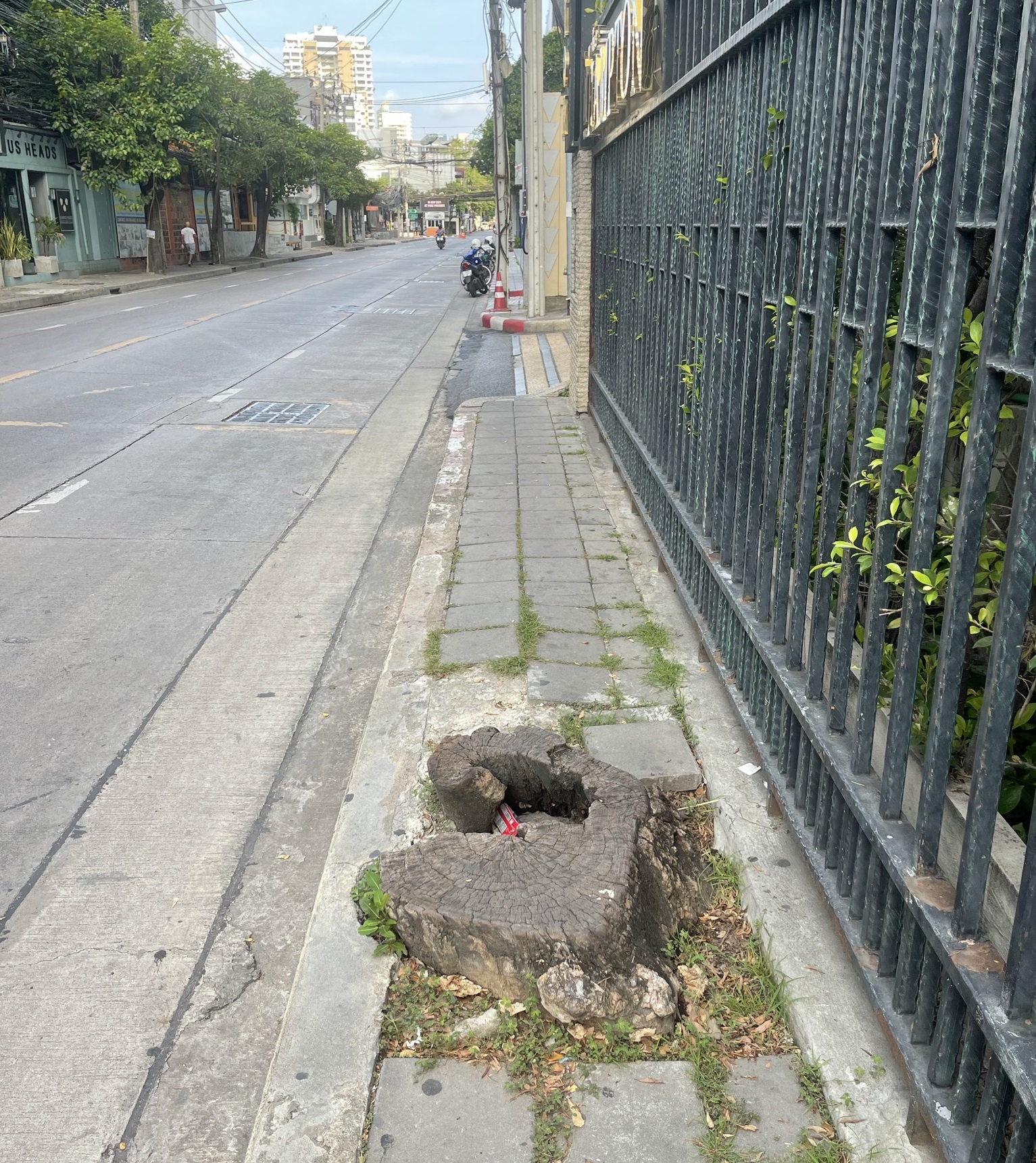
As the sky gradually lightens, I run in the street as it is still a bit safer than running on the footpaths, which are inconsistently leveled and often have obstacles (tree stumps, anyone?) and loose pavers that will give way and twist your ankle.

I take different routes, exploring familiar corners of the neighborhood I pass by frequently in a car as well as hidden troks, the narrow lanes that weave behind temples, along canals, and in areas not accessible to vehicles with four wheels. It is a chance to see more about the neighborhoods along the middle of Sukhumvit Road.

One of the more fascinating aspects of this part of Bangkok is its socioeconomic diversity. To be clear, the part of Sukhumvit Road stretching from Asoke (Sukhumvit 21) to Pridi Banomyong (Sukhumvit 71) – a five-kilometer stretch – is the wealthiest section of Bangkok. But behind the malls, high-rise luxury condos, nightclubs, Michelin-starred restaurants, and import car dealerships, you find these pockets of everything from modest 1960s-era apartments to slums and cramped construction worker shacks, the last of which have facilitated the rapid spread of COVID-19.

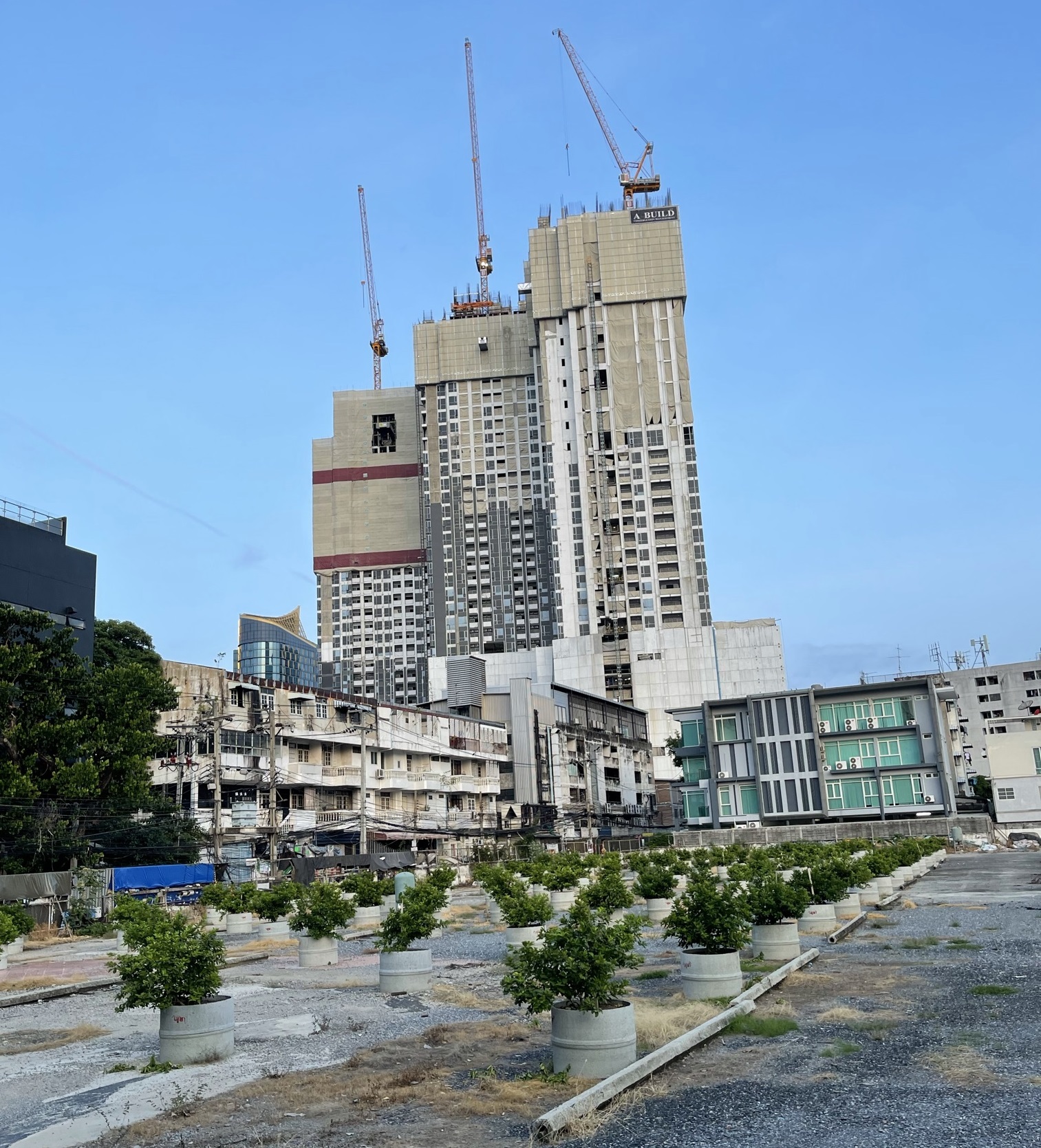
The four-story shop houses, which were the staple of the main streets, continue to give way to 30-, 40- and 50-story condo towers, many of which have prices starting at US$6,000 per square meter (10 square feet) and going much, much higher. In the past two years, the government finally instituted an annual property tax, although they are giving a 90% discount off the already low tax rate. Under-utilized land is taxed at a higher rate so, as you see in the picture above, vacant land is being planted with lime or banana trees, to be classified as an agricultural use while the owners await the opportunity to otherwise develop it.

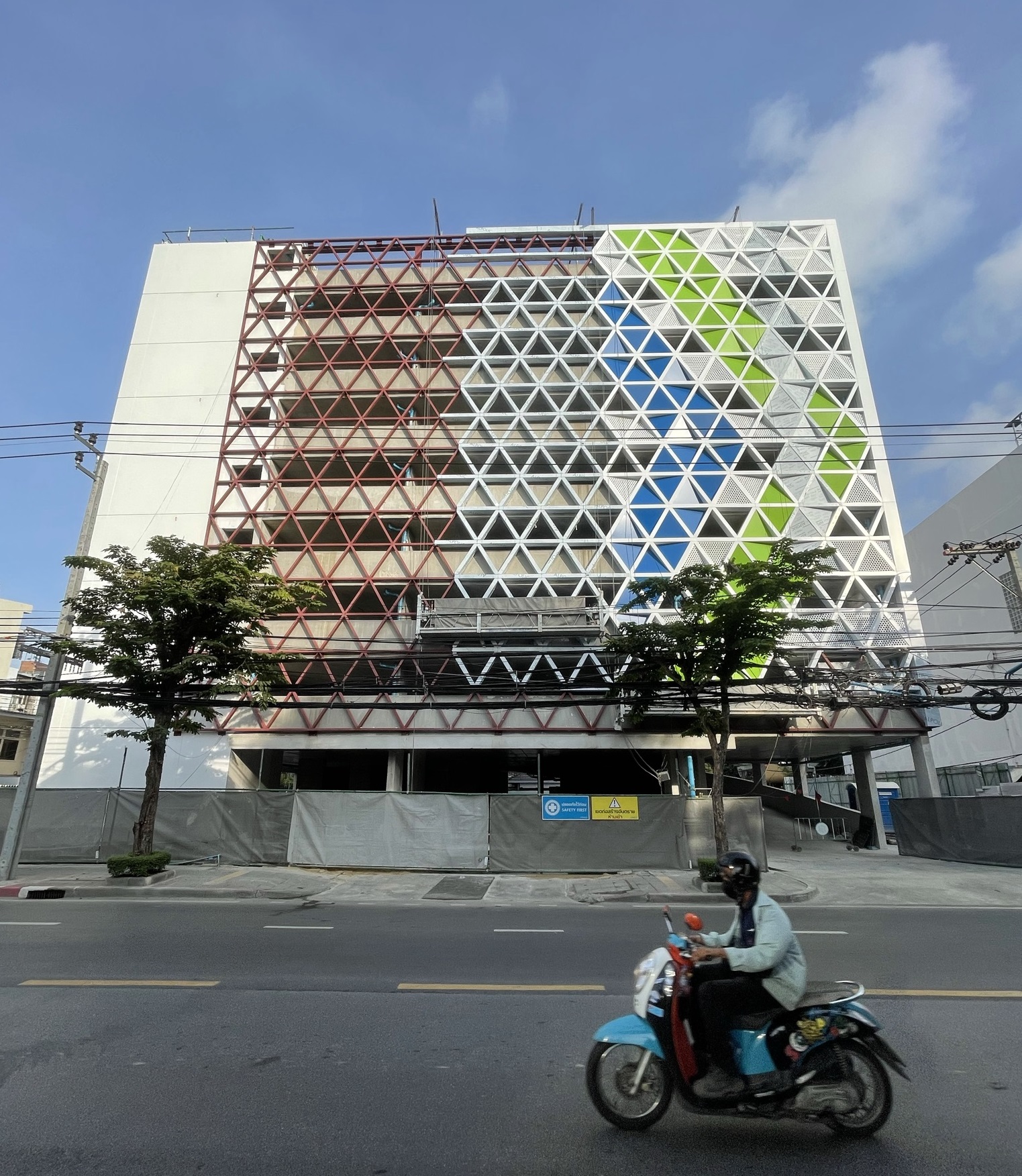
One recent addition on Ekkamai Road, a hot spot for nightlife, is the addition of a privately-run multi-story car park, the first I recall seeing in this area. Given how car-centric Bangkok is, this is probably a good idea and may perhaps some of the annoying parking that clogs narrow sois and alleys.

There are pockets of culture to be found. This narrow khlong that cuts through the back part of the neighborhood between Thong Lor and Ekkamai roads, has provided a canvas for graffiti artists, something that was rare when I moved here in 2005 but now seems more common and, frankly, in many cases quite sophisticated. The water, though, is dreadful and I can imagine that the neighbors keep their windows closed even when the weather turns a bit more pleasant in the winter.

Hidden next to the 150-year old khlong Saen Saeb, one of the oldest canals in Bangkok, is the charming Wat Pasi (or “tax temple”). It is popular with locals and has unique square-shaped main building that looks much more like a mosque than the typically steeply-pitched red tiled roof on a Buddhist temple. The temple is actually very close to a large Muslim population and about five minutes along the canal, you will find Khlongtan Central Mosque or Masjid Jamiah al-Islam, a prominent mosque in this area.

Interestingly, in the last few years, Wat Pasi has undergone this redecoration with this tree trunks (real trees!) shipped here and set up to create a faux-forest scene. I’m unclear why the trees needed to be cut down instead of new trees being planted.

Anyhow, the chance to run around the neighborhood helps me see more of the area, appreciate the range of lives and lifestyles that are here, many of which are largely invisible to me unless I go looking for them.

Bicycling Around Ekkamai

Sunday morning I jumped back on my bicycle and went for a ride through the neighborhood.  What interesting things there are to be seen!

P1050391 I didn’t realize that I lived near a store that sells plastic models of food.  Not only the ones you expect to see outside Japanese restaurants, but also ones for Chinese, Thai and Western cuisines. 

What a perfect gift for someone for Christmas: a slice of cake that you can never eat!

Sadly, they were closed on Sunday morning so I couldn’t pop in for a visit.  They would probably freak out if I started taking pictures inside the store, though.  That seems to really be an issue at businesses here in Thailand.

P1050405 I continued up Ekkamai Road, which is Sukhumvit Soi 63, and stopped at Ekkamai Soi 26 to take a picture I’ve long been meaning to take. 

Someone, for reasons unknown, decided to post a street sign on the corner of the soi in the style of the signs that grace Parisian street corners.  Interestingly, the person who made or ordered the sign decided to place Ekkamai Soi 26 in the 18th Arrondissement.

Perhaps there is a clue to be had from the fact that the 18th Arrondissement is Montmartre, the artsy residential district.  Further exploration is called for but the fact that there is a frame shop below the sign might yield some answers.

My route continued north, crossing Khlong San Saeb, the primary east-west canal in the city and the only one that has any scheduled passenger boat service on it.  You can actually take the canal taxis all the way into the old city, an efficient and inexpensive way to travel.

The khlong has pedestrian paths on either side and I have explored those before.  In some parts of the khlong, nice houses back up to it.  In other parts, the pedestrian paths cut through the shacks and shanties of some very poor families.  Also, in the Thong Lor / Ekkamai area, there is a prominent Muslim community that lives near the khlong with one mosque near Thong Lor and another past Ekkamai.  There are so many interesting communities here and you just don’t see them if you stay in a car.

P1050415

Above: On Ekkamai flyover above Phetchaburi Road, there is an interesting Buddhist temple (gold pagoda on top) called Wat Ekkamai Pasi, literally, the “Ekkamai tax temple”.  Next to it is the large Charn Issara 2 office building.  Such a contrast!  And in the cloverleaf formed by the ramps leading to the flyover, there is a small park that includes basketball, badminton, and football courts.

Beyond Phetchaburi Road is (below from left to right) the old State Railway line, the new Airport Express viaduct, and the maintenance facility for the Airport Express.  To the left of the railway line is a small market and, with the red roof, the Khlongtan railway station.  The track is currently used for commute rail services to the east as well as longer-distance trains that run to the Cambodian border and up to Northeast Thailand.

P1050422

The maintenance facility is coming along nicely.  If you look closely in the picture below you’ll see that the first piece of rolling stock has arrived.

P1050419

How much longer until the Airport Express is running?  Well, if you time your trip for late 2009, it should be running sometime around then.  Meanwhile, if you arrive earlier, give me a call and I’ll come pick you up!


Civil engineering update: Airport Link

For you civil engineering buffs, here’s an update on some of the work happening at the Suvarnabhumi Airport Rail Link construction site.  First, a little background:

The Airport Link is a 28.6 km (17.7 mile) mostly elevated train way that will serve as the eastern half of the “Light Red Line” in Khrungthep’s master transit plan.  The western half of the line is a planned extension north to connect to Don Meuang domestic airport, with no specific time frame in which that will occur.  Started in 2005, construction of the eastern half is expected to be finished sometime in late 2008, with recent news reports puting the construction at a 70% completion rate as of this point.  Both local and express services will be offered on the line. 

P1020198

Above: “We apologize for any inconvenience as we build the maintenance complex for the airport train.”  The picture is of the delivery of the first of nine Siemens Desiro class 360/2 trainsets arrives in Thailand.

The express train will run from the Makkasan City Air Terminal (at the corner of Phetburi and Asoke Roads, where you will be able to connect with the MRT subway Blue Line) to the basement level of Suvarnabhumi Airport in 15 minutes.  It is expected that you will be able to check in for flights at the Makkasan CAT, receiving your boarding pass and handing over your checked baggage, just like at the Airport Express terminal in Hong Kong.

The local train will run from the Phaya Thai station, (where you will be able to connect with the BTS Skytrain Sukhumvit Line), stopping at Ratchaprarop, Makkasan, then at four additional stops before arriving at the airport.  The total trip time for the local service will be 27 minutes.  The initial plans had several additional stops along the lines, including one at Royal City Avenue, a popular nightlife and entertainment district.  It appears that those stops will not be built at this time but just based on my own visual assessment of the construction in the RCA area, it looks like the tracks are being constructed in such a way that a station could be added in the future. 

The Airport Link’s maintenance yard and depot will be in the Soonvijai district, an area on the north side of Phetburi Road from roughly Thong Lor to Ekkamai.  Bangkok Hospital is located just to the west of this area and Tawn’s parents live just on the other side of Ekkamai Road, to the east of this area.

Sunday morning while running errands I stopped to snap some photos of the construction:

P1020050

Above: From the Ekkamai Road flyover, looking west.  On the left is the Soonvijai train station with a train stopping momentarily before continuing on to Hua Lamphong Station.  On the far side of the buildings that face the train station is Phetburi Road.  Bangkok Hospital is the white building on the right hand side of the picture, behind the construction site.  The elevated track is clearly visible on the left and the ramp where trains will exit and enter the main line is being built along the elevated track in the center of the picture.  The maintenance sheds are under construction in the center and right side of the picture.

Below: Taken from the other end of the above picture and looking to the east, you can see the construction of the exit/entry ramp where trains will connect with the elevated line (right) via the ramp (center).  The Soonvijai station is on the right side of the ground-level rail line, now occupied as the train has left the station.

P1020192

Below: Turning around from the above picture and looking west along the tracks, towards Makkasan Station.  The Royal City Avenue sign that is blocked by construction is a bit deceptive.  Before construction started, there was a frontage road along the rail tracks that you could drinve from the area where the picture was taken (which is essentially the entrance to Bangkok Hospital) to the entrance of the RCA entertainment district about 300 meters to the west.  That road is gone and, I assume, will not reopen.

P1020195

P1020201

Above: A look inside one of the mainenance sheds, where you can see the rails have been laid and the catwalks that will run along the side of the trains have already been installed.

For more information, 2bangkok.com maintains a space dedicated to this project.